


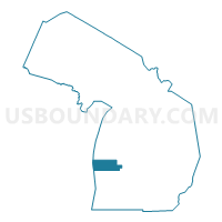
Muskegon County PUMA, Michigan
About
Outline

Summary
| Unique Area Identifier | 193149 |
| Name | Muskegon County PUMA |
| State | Michigan |
| Area (square miles) | 1,460.02 |
| Land Area (square miles) | 499.25 |
| Water Area (square miles) | 960.78 |
| % of Land Area | 34.19 |
| % of Water Area | 65.81 |
| Latitude of the Internal Point | 43.26641580 |
| Longtitude of the Internal Point | -86.75432900 |
Maps

Graphs
Select a template below for downloading or customizing gragh for Muskegon County PUMA, Michigan


Neighbors
Neighoring Public Use Microdata Area (by Name) Neighboring Public Use Microdata Area on the Map
- Kent County (North) PUMA, MI
- Milwaukee County (South) PUMA, WI
- Newaygo, Mason, Oceana & Lake Counties PUMA, MI
- Ottawa County (East) PUMA, MI
- Ottawa County (West) PUMA, MI
- Washington & Ozaukee Counties PUMA, WI
Top 10 Neighboring County (by Population) Neighboring County on the Map
- Milwaukee County, WI (947,735)
- Kent County, MI (602,622)
- Ottawa County, MI (263,801)
- Muskegon County, MI (172,188)
- Ozaukee County, WI (86,395)
- Newaygo County, MI (48,460)
- Oceana County, MI (26,570)
Top 10 Neighboring County Subdivision (by Population) Neighboring County Subdivision on the Map
- Muskegon city, Muskegon County, MI (38,401)
- Norton Shores city, Muskegon County, MI (23,994)
- Muskegon charter township, Muskegon County, MI (17,840)
- Spring Lake township, Ottawa County, MI (14,300)
- Fruitport charter township, Muskegon County, MI (13,598)
- Muskegon Heights city, Muskegon County, MI (10,856)
- Egelston township, Muskegon County, MI (9,909)
- Dalton township, Muskegon County, MI (9,300)
- Sparta township, Kent County, MI (9,110)
- Laketon township, Muskegon County, MI (7,563)
Top 10 Neighboring Place (by Population) Neighboring Place on the Map
- Muskegon city, MI (38,401)
- Norton Shores city, MI (23,994)
- Muskegon Heights city, MI (10,856)
- Wolf Lake CDP, MI (4,104)
- Roosevelt Park city, MI (3,831)
- North Muskegon city, MI (3,786)
- Whitehall city, MI (2,706)
- Montague city, MI (2,361)
- Twin Lake CDP, MI (1,720)
- Lakewood Club village, MI (1,291)
Top 10 Neighboring Unified School District (by Population) Neighboring Unified School District on the Map
- Grand Haven Area Public Schools, MI (39,731)
- Muskegon City School District, MI (36,988)
- Mona Shores Public School District, MI (23,104)
- Reeths-Puffer Schools, MI (21,505)
- Fruitport Community Schools, MI (17,961)
- Orchard View Schools, MI (16,917)
- Sparta Area Schools, MI (14,313)
- Fremont Public School District, MI (13,641)
- Coopersville Public School District, MI (12,816)
- Spring Lake Public Schools, MI (12,155)
Top 10 Neighboring State Legislative District Lower Chamber (by Population) Neighboring State Legislative District Lower Chamber on the Map
- State House District 73, MI (105,447)
- State House District 74, MI (97,079)
- State House District 89, MI (96,358)
- State House District 91, MI (90,216)
- State House District 100, MI (86,569)
- State House District 92, MI (83,989)
- Assembly District 60, WI (57,434)
- Assembly District 22, WI (53,017)
Top 10 Neighboring State Legislative District Upper Chamber (by Population) Neighboring State Legislative District Upper Chamber on the Map
- State Senate District 28, MI (306,724)
- State Senate District 30, MI (288,289)
- State Senate District 34, MI (275,923)
- State Senate District 20, WI (176,381)
- State Senate District 8, WI (165,331)
Top 10 Neighboring 111th Congressional District (by Population) Neighboring 111th Congressional District on the Map
Top 10 Neighboring Census Tract (by Population) Neighboring Census Tract on the Map
- Census Tract 27, Muskegon County, MI (7,653)
- Census Tract 25, Muskegon County, MI (7,577)
- Census Tract 103, Oceana County, MI (7,045)
- Census Tract 36, Muskegon County, MI (6,578)
- Census Tract 28, Muskegon County, MI (5,945)
- Census Tract 106, Oceana County, MI (5,703)
- Census Tract 23, Muskegon County, MI (5,699)
- Census Tract 37, Muskegon County, MI (5,487)
- Census Tract 29, Muskegon County, MI (5,346)
- Census Tract 9704, Newaygo County, MI (5,187)
Top 10 Neighboring 5-Digit ZIP Code Tabulation Area (by Population) Neighboring 5-Digit ZIP Code Tabulation Area on the Map
- 49442, MI (41,214)
- 49441, MI (36,308)
- 49444, MI (29,456)
- 49445, MI (20,784)
- 49456, MI (18,581)
- 49412, MI (11,065)
- 49457, MI (10,565)
- 49461, MI (8,929)
- 49327, MI (8,406)
- 49404, MI (8,269)